
Mammatus Clouds: A Guide to Their Formation and Appearance
Mammatus clouds are captivating atmospheric phenomena that have fascinated observers for centuries. These unique cloud formations, resembling pouches hanging beneath larger clouds, offer a glimpse into the complex interplay of weather patterns and atmospheric conditions. Understanding mammatus clouds involves exploring their formation mechanisms, identifying different types, and considering their potential impact on weather systems. This article aims to provide a comprehensive guide to these intriguing clouds, delving into their scientific explanations, cultural significance, and safety considerations.
The objective is to present a detailed analysis of mammatus clouds, covering their definition, atmospheric conditions necessary for formation, various types observed in different regions, potential causes and theories, and their role in weather patterns. Additionally, the article will discuss observing techniques, safety precautions when encountering these clouds, cultural interpretations, and concluding remarks on their enduring fascination. By exploring these aspects, readers will gain a deeper appreciation for the scientific wonder and symbolic meaning associated with bubble clouds.
Contents
What are Mammatus Clouds?
Mammatus clouds are distinctive cloud formations that appear as pouches or bags hanging beneath larger cumulus or stratus clouds. These clouds often develop in unstable atmospheric conditions, where rising air currents collide with cooler air masses. The unique shape of mammatus clouds arises from the interaction between these air masses and the condensation process within the cloud.
The formation of bubble clouds is closely linked to the freezing and thawing of water droplets within the cloud. As warm air rises, it cools and condenses, forming water droplets that coalesce into visible clouds. When these droplets freeze, they can create a unique depression in the cloud structure, resembling a pouch or bag. This phenomenon is often observed during thunderstorms or other weather events with significant atmospheric instability.
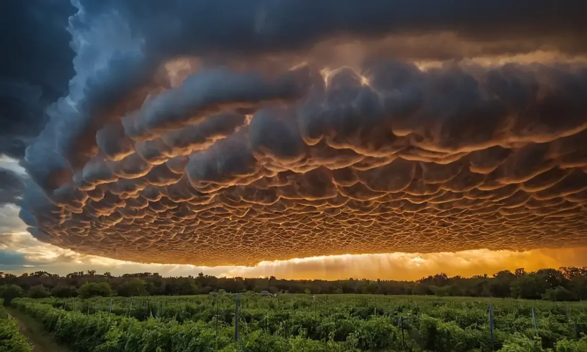
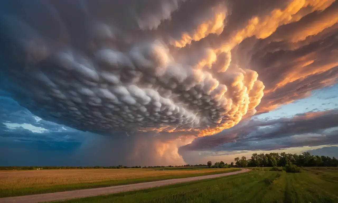
The name "mammatus" originates from the Latin word for breast or udder, reflecting the resemblance of these cloud formations to mammary glands. This descriptive term highlights the visual similarity between the cloud's shape and the appearance of a human breast. The presence of these pouches can be subtle in some cases, resembling bubble wrap, while in others they become more pronounced, resembling cow udders.
Formation and Atmospheric Conditions
Mammatus clouds typically form under specific atmospheric conditions that promote instability and vertical air movement. These conditions are often associated with strong winds, rising thermals, or the presence of a frontal system. When warm, moist air encounters cooler air masses, it can rise rapidly, creating updrafts that fuel cloud formation.
The interaction between these air masses is crucial for bubble cloud development. As warm air rises, it cools and condenses, forming water droplets within the cloud. These droplets then freeze as they reach their saturation point, leading to the formation of ice crystals. The freezing process can create a depression in the cloud structure, resulting in the characteristic pouch-like appearance of mammatus clouds.
Several factors influence the development of these clouds. One key factor is atmospheric instability, which refers to the difference in air pressure between different levels of the atmosphere. When there's a significant pressure gradient, air tends to rise rapidly, creating updrafts that fuel cloud formation. This process can be further enhanced by the presence of moisture, as water vapor provides the necessary ingredients for cloud condensation and growth.
Types of Mammatus Clouds
Mammatus clouds exhibit diverse shapes and sizes, depending on various factors like atmospheric conditions, wind patterns, and altitude. While they are often associated with thunderstorms, their occurrence can be observed in other weather events as well.
One common type is the "classic mammatus cloud," characterized by distinct pouches hanging beneath larger cumulus or stratus clouds. These clouds typically develop during unstable atmospheric conditions, such as those found during warm fronts or after periods of strong thunderstorms. Another type is the "inverted mammatus cloud," where the pouch-like structure appears inverted, with the bottom of the pouch facing upwards. This type is often observed in situations involving strong updrafts and vertical air movement.
The size and prominence of mammatus clouds can vary significantly depending on the atmospheric conditions. Small, subtle pouches may be barely noticeable against the larger cloud background, while more pronounced formations can resemble cow udders or even large bags hanging from the sky. The appearance of these clouds is often influenced by factors like wind speed and direction, as well as the altitude at which they form.
Causes and Theories
Several theories attempt to explain the formation of bubble clouds. One prominent theory suggests that the development of mammatus clouds is linked to the freezing and thawing of water droplets within the cloud. As warm air rises, it cools and condenses, forming water droplets that eventually freeze into ice crystals.
The freezing process can create a depression in the cloud structure, leading to the formation of the characteristic pouch-like shape. This theory aligns with observations where mammatus clouds often appear alongside thunderstorms or other weather events involving significant atmospheric instability. Another theory suggests that the presence of strong updrafts within the cloud plays a role in shaping these formations.
Strong updrafts can create vertical air currents that drive the formation and growth of bubble clouds. As warm, moist air rises rapidly, it encounters cooler air masses, leading to condensation and the subsequent freezing of water droplets. This process can result in the creation of depressions within the cloud structure, contributing to the development of mammatus formations.
Impact on Weather Patterns
Mammatus clouds play a role in weather patterns by influencing atmospheric stability and moisture transport. Their presence can indicate changes in wind direction or speed, potentially impacting local weather conditions. Additionally, their formation can contribute to the development of other cloud types, such as cumulonimbus clouds, which are known for their heavy precipitation potential.
The interaction between bubble clouds and larger weather systems can influence atmospheric circulation patterns. For instance, if a mammatus cloud forms near a front, it could disrupt the flow of air masses, potentially leading to changes in wind direction or speed. This disruption can have cascading effects on local weather patterns, influencing precipitation rates and overall atmospheric stability.
Observing and Identifying Mammatus Clouds
Observing mammatus clouds requires keen observation skills and an understanding of their typical characteristics. These clouds are often visible as distinct pouches hanging beneath larger cloud formations, particularly during thunderstorms or other unstable atmospheric conditions.
When observing these clouds, it's crucial to consider the context in which they appear. Mammatus clouds are most commonly observed during periods of strong winds, rising thermals, or after periods of heavy precipitation. Additionally, their presence can be indicated by changes in cloud structure or a sudden shift in wind direction.
Identifying mammatus clouds involves paying close attention to the overall cloud formation and its surrounding environment. Observing the shape, size, and location of these clouds relative to other weather phenomena can provide valuable insights into their formation and potential impact on local weather patterns.
Safety Precautions and Considerations
While observing bubble clouds is generally safe, it's essential to exercise caution when encountering them in real-life situations. These clouds are often associated with thunderstorms or other severe weather events, which can pose safety risks.
When venturing into areas where mammatus clouds are present, it's crucial to be aware of the potential hazards associated with these formations. This includes lightning strikes, strong winds, and hailstorms. It is advisable to seek shelter in safe locations during such conditions and avoid unnecessary exposure to potentially hazardous weather events.
Additionally, when observing bubble clouds from a distance, it's important to maintain a safe distance and avoid getting too close to the cloud formations. This precaution helps minimize personal risk and ensures everyone's safety during observation.
Cultural Significance and Symbolism
Mammatus clouds have held cultural significance in various societies throughout history. Their unique appearance has inspired artists, writers, and storytellers, leading to their inclusion in folklore, mythology, and literature.
In some cultures, bubble clouds are associated with spirits or deities, symbolizing the power of nature or the passage of time. These beliefs often reflect a deep connection between humans and the natural world, highlighting the awe-inspiring beauty and mystery of weather phenomena.
For example, in Native American folklore, mammatus clouds are sometimes seen as harbingers of change or messengers from the spirit realm. Their presence can be interpreted as a sign of impending events or a reminder of the interconnectedness between humans and the natural world.
Conclusion
Mammatus clouds are fascinating weather phenomena that continue to intrigue scientists and observers alike. Their unique appearance, diverse types, and potential impact on local weather patterns make them a subject of ongoing research and observation. Understanding their formation, characteristics, and cultural significance can enhance our appreciation for the dynamic nature of our planet's atmosphere.
Firefighting: Fighting Fire With Controlled Burns

Niagara Falls: Freezing Conditions & Unique Ice Formations

Mountains: Formation by Tectonic Activity

Galveston Hurricane: A Devastating Legacy of Nature's Fury

Asteroid Impact: Threat & Mitigation Efforts

Lightning Strikes: A Journey Through Ionized Air
Leave a Reply
Related Links